Pages

Thursday, June 30, 2022

ECUADOR, GALAPAGOS ISLANDS: CROSSING THE EQUATOR

 March 24, 2022, Late afternoon and evening

The first time Bob and I crossed the equator was in 2009 when we flew over it on our way to Peru. The first time we crossed the equator at ground level was on our trip to Kenya in 2014. We crossed the equator by air several more times before this trip, and we crossed it on foot and by car in Quito, but our trip to the Galapagos was the first time we crossed the equator on the water.

We were not quite prepared for what it means to cross the equator on a boat.

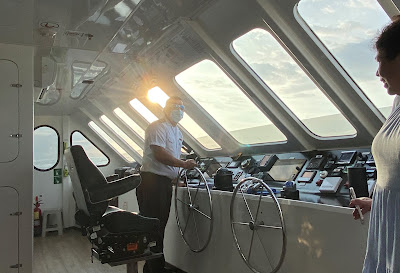
First, we all gathered in the wheelhouse with the captain to take a look at the instruments that indicated exactly where we were on the earth's surface.

Somewhere out there was the equator, but we couldn't see it.

In days past, a sextant was used to determine latitude, but these days a sophisticated, digital instrument panel makes it much easier. We all crowded in and got our cameras ready to take a picture of the GPS display when we crossed the equator.

The equator is at 0*00.000, but I missed it by .003. (We were traveling south to north, so this is just after crossing.)

Sunday, June 26, 2022

ECUADOR, GALAPAGOS ISLANDS: ISABELA ISLAND - TAGUS COVE PANGA RIDE AND EQUATOR CROSSING

 March 24, 2022, Afternoon and Evening

In the afternoon we took a panga trip to Vincente Roca Point, the northernmost site on Isabela Island. It is supposed to be a fantastic area for snorkeling, but the water was very murky.


I could see the great swaths of bubbles that Bob said had a soapy taste.


Close up, it didn't look like bubbles at all--more like DNA chains.


Wednesday, June 22, 2022

ECUADOR, GALAPAGOS ISLANDS: ISABELA ISLAND - TAGUS COVE HIKE

March 24, 2022, Morning and Lunch

During the night our catamaran left Fernandina Island and returned to Isabela Island, dropping anchor just off Tagus Cove on the northwestern coast of the island.

We got up early for a 6:00 AM breakfast, and by 7:00 we were in pangas on our way to a dry landing at Tagus Cove.

Tagus Cove was visited by Charles Darwin in 1835 and has always been a hideout for pirates, whalers, and other sea voyagers. The cove gets its name from a British ship, the Tagus, that anchored there in 1814 looking for some of the giant tortoises to replenish their food supply.

Starting in the early 19th century, visitors to this site began carving their name and the year into the cliff. (It just takes one to start a trend.) 

The oldest is this one: 1836.

The practice was outlawed when the Galapagos National Park was established in 1959-1960, although I see "Feb 1974 Oceana" on the right. Clearly this was before tourists had to be accompanied by a naturalist!

Saturday, June 18, 2022

ECUADOR, GALAPAGOS ISLANDS: FERNANDINA ISLAND - ESPINOZA POINT

 March 23, 2022, Afternoon

The last expedition of the day was a walking excursion on Fernandina Island, an island next to Isabela Island, where we had spent the morning and the previous day. Our naturalist guide Fernanda told us Fernandina is her favorite island in the Galapagos, and not just because of the similarity to her name. She was excited to show it to us.

With the good omen of a rainbow behind us, we set out in the pangas for a dry docking on Fernandina Island. Our two-hour visit there may be our favorite experience of the entire Galapagos trip, and possibly one of our favorite travel experiences of all time.


We disembarked directly from the panga onto a short length of concrete that acted like a pier. We were the second panga in, and we wondered what everyone from the first panga was taking pictures of. When we got to that spot, we saw this green marine iguana crawling out of the water.

When we were only about 10 yards farther down the trail, we started hearing gasps from those in front of us, and when we could  see what they were looking at, we gasped too. A clearing was jam-packed with completely motionless marine iguanas--hundreds of them--some unceremoniously stacked on top of others, and they didn't even bother to acknowledge our presence. 

Tuesday, June 14, 2022

ECUADOR, GALAPAGOS ISLANDS: ISABELA ISLAND - URBINA BAY

 Wednesday, March 23, 2022, Morning

Every night after dinner, the crew would put the next day's itinerary on a giant TV screen so we could plan clothing, etc. Our second day would include two landings: one wet and one dry.


When we woke up the next morning, we had this view from our cabin window. 

After breakfast, we motored to Urbina Bay on Isabela Island. Bob took this photo of the Bay later in the day:

Our morning excursion required us to get out of the panga in knee-deep water (a "wet" landing).  The coarse volcanic sand of the beach wasn't very hospitable, and neither was the skull. Was it a warning of some kind? It was also already quite hot and very humid.  


Friday, June 10, 2022

ECUADOR, GALAPAGOS ISLANDS: ISABELA ISLAND - PUNTA MORENO AND ELIZABETH BAY

 March 22, 2022

During the night we sailed from Puerto Ayora to Punta Moreno, located on the largest of the Galapagos Islands, Isla Isabela. We spent the morning boating around Punta Moreno, and in the afternoon we traveled a little further up the coastline to Elizabeth Bay, shown below.

We had thought that being on a triple-hulled boat meant more stability in the water, but that was not the case, and during my first night on the Alya I did serious battle with my nemesis, motion sickness. Thank goodness we had a private bathroom. In spite of scopolamine patches and Dramamine, I felt queasy to some degree the entire trip, which was a bummer.

However, the next morning I was able to keep my breakfast down and join the others on an inflatable motorized raft, which I learned is called a panga, for an expedition to explore the coastline of Punta Moreno on the island of Isabela. There it is in the distance, as seen from our catamaran:


The Alya had two pangas, and every time we left the catamaran, we split our group of 19 (8 couples, 1 naturalist, 2 panga skippers) between the two.

We were not allowed to actually land and disembark on this day, but we still had some amazing experiences.

First, we pulled up alongside a coastline covered with a dense mangrove thicket.

As we got close, we saw that the trees were full of pelican nests.

Pelicans are huge, clumsy-looking birds with what looks like a toupee instead of feathers on their wings--at least from this angle.

Monday, June 6, 2022

ECUADOR: TRAVELING TO THE GALAPAGOS ISLANDS AND VISITING BALTRA AND SANTA CRUZ ISLANDS

 March 21, 2022

After our full day in Quito, we were ready to head to the Galapagos Islands. Our hotel in Quito was one or two blocks from the airport, and the hotel had a shuttle ready for the eight of us at 7:00 AM. There were some confusing things to do at the airport, like have our bags run through x-ray before security as well as fill out some forms in a different location of the airport. It was by no means a clear process.

The Galapagos Islands straddle the equator 563 miles west of continental Ecuador. Flights leave for the islands from Guayaquil, so we had to fly there first (45 minute flight). It was fun to see the Guayaquil LDS Temple both on landing and take-off.


The second leg of the flight, from Guayaquil to the Galapagos Islands, was about 1.5 hours. This map isn't to scale (the islands are MUCH smaller in relation to the continent), but it at least gives a good idea of the location and number of the islands. There are 13 major islands and more than 100 smaller islands in the chain.
Map from here


Two airports are used for tourism in the Galapagos. We landed at the one on the island of Baltra, a tiny desert island separated from the much larger island of Santa Cruz by a narrow channel. (The other airport is on the island of San Cristobal.)

We disembarked old-style down a flight of stairs wheeled up to the plane.

The airport itself is quite small.

After two long years of pandemic waiting, we were very excited to finally be on the Galapagos Islands!


Thursday, June 2, 2022

ECUADOR: QUITO-IN-A-DAY

 March 21, 2022

Quito is the capital and largest city in Ecuador. Situated in a valley in the Andean foothills at 9,350 feet, it is the second-highest capital city in the world (La Paz, Bolivia, sits at 11,942 feet) and the capital city closest to the equator. It is the only capital city next to an active volcano, Pichinca, which stands at 15,728 feet. Its last major eruption was in 1660, but it did puff a fair amount of ash onto Quito in 1999. Quito has, however, had a significant number of large-magnitude earthquakes in the last 100 or so years, including two that were stronger than 8.0 in magnitude: 8.8 in 1906, 8.2 in 1979, and nine stronger than 7.0 since 1942. Yikes.

Founded by the Spanish in 1534 on the ruins of an Inca city, Quito proper covers 143 square miles and has a population of 2.8 million, and we had about ten hours to see it all.

In the morning we met up with Terry and Geneil and enjoyed an upgraded breakfast on the "club floor" with them, (Remember, Terry had been upgraded because it was his birthday.)


Beautiful flowers--of course--and passion fruit.

Afterwards we gathered in the lobby with the other two couples who were joining our group, Brian and Renee Bascom and Ward and Norma Robinson, who had arrived in Quito in the last day or so.

A guide and driver picked up the eight of us and we were on the road by 9:00 AM. Our first stop was the Itanim Middle of the World Museum.

Here we all are!