June 14, 2019
Our next stop on our Grand Northern Adventure was Greenland, conveniently marked in green (of course) below:
At about 840,000 square miles, Greenland is the largest island in the world, almost three times as large as the next largest island, New Guinea. (Of course, Australia is more than three times as large as Greenland, but it is considered a continent, not an island.)
Iceland is a mere 40,000 square miles, so Greenland is twenty-one times larger. But while Greenland has a population of about 56,000 people, Iceland has about 340,000 people, or six times as many.
By comparison, the contiguous 48 states in the US comprise about 3.1 million square miles, which is 3.7 times larger than Greenland. Alaska, perhaps a better comparison, is just over 663,000 square miles, about four-fifths the size of Greenland. In contrast, the population of Alaska is about 737,000 people, about 13 times the population of Greenland, and the population of the 48 contiguous states is about 327 million, almost 6,000 times the population of Greenland.
That's not surprising considering that most of Greenland is inside the Arctic Circle, which doesn't make for great farming or raising of livestock (although it is great for fishing), and which means the summers are very short and the winters are very, very long.
 |
| Map from Wikipedia |
 There are only two cities that offer flights in and out of Greenland: Reykjavik (Iceland) and Copenhagen (Denmark). All other flights to Greenland connect in these two cities. Greenland doesn't get a lot of tourists. I think this chart from Wikipedia showing the number of overnight visitors in 2016 is very interesting.
If you are wondering why so many more visitors come from Denmark than the other Scandinavian countries, it is because Greenland is an autonomous Danish territory, so there are many economic and cultural ties between the two countries. I would think Iceland and Canada, Greenland's closest neighbors, would be sending more tourists, but apparently Greenland doesn't have much appeal for them.
But back to the trip. We flew out of the Reykjavik Airport, a small domestic airport, rather than the international airport where we had arrived. Our Air Iceland Connect propeller plane carried thirty-six people, one flight attendant, and the pilot (two pilots?). Our flight lasted about three hours, and we were given a pretty good ham and cheese-filled croissant for lunch.
I had a good view of the propeller out of my window, so I filmed it to see what it looked like. It looks like I was filming on slo-mo mode, but I filmed on regular speed, and yet the propeller appears to be rotating very slowly and the blades seem to be bending like soft rubber. Someone who understands physics please explain this to me.
Instructions in both English and Icelandic are on the first page of of the journal, and inspirational quotes are sprinkled throughout the pages.
There are some fun drawings along with the travel musings. Click on the photo to make it large enough to read the words:
I especially liked this entry on the left, and it was fun to add my own review of our time in Iceland:
Kudos to Air Iceland for encouraging writing and storytelling!
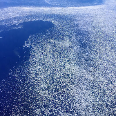
When I wasn't reading and writing, I was looking out the window. For most of the trip we flew below the clouds, and from the very beginning, the view out the window was spectacular. As we flew away from the northwestern coast of Iceland, we saw millions of icebergs dotting the sapphire-colored water:
It looked almost like a pointillist painting:
Craggy peaks pierce the glaciers, and deep fjords slash into the coastline:
We flew from Reykjavik across Greenland to Ilulissat on the west coast. There were no visible settlements or roads on the interior of Greenland. Ilulissat sits within the Arctic Circle. The capital of the country, Nuuk, 350 miles south of Ilulissat, is well below the Arctic Circle.The white areas on the map below are all glaciers. Other than the national park, which is not populated, all the population areas are on the coast.
One interesting fact about Greenland is that there are no roads that connect villages/towns. All travel between populated areas is done by boat, plane, dog sleds, or snowmobiles.
What good would a road do in terrain like this?
As we reached the east coast, we began to see land not blanketed in snow:
We had a great view of Disko Bay, which is right off the coast of Ilulissat:
We also flew right over the Ilulissat Glacier, which calves into the Ilulissat Icefjord:
It was my first view of a lake on a glacier, something we learned more about later in the trip:
As we got closer and lower, the booming metropolis of Ilulissat, the third largest village in Greenland with a population about 5,000, came into view:
The Ilulissat Airport has a rather short runway, so it's a good thing we were in a rather small plane:
 |
| Photo from Wikipedia |
And here we go, ready for part two of our adventure!


I love the east coast of Iceland - the jagged coast line, mountains, glaciers and icebergs. What a wonderful place.
ReplyDeleteI love that journal!! (and so glad you added to it)
ReplyDelete