
October 18, 2020
We had one more highpoint to summit on this trip: Black Mesa, the highest point in Oklahoma. One of the interesting thing about this highpoint is that Black Mesa actually extends into Colorado and New Mexico, and the highpoint in both of those other states is higher than the highpoint in Oklahoma (but is not the highpoint in those states).

We left our hotel at about 7:00 AM and drove an hour to the trailhead. When we began our hike just after 8:00, it was only 36° F. I wrote in my notes that I was wearing 2 pairs of pants, a long-sleeved shirt, a Columbia zip jacket, a down jacket, and Bob's gloves. (Thanks, dear.)

The round trip hike was 8.4 miles, and when we got back to the car at 11:30, it was 39°. It was cold, but we kept up a quick pace and it wasn't too bad--until we got to the mesa itself.
Just before the gate is this granite bench honoring Jean Trousdale, "Highpointers Foundation Director, Founder of the Club Mercantile, Clinical Psychologist, Mother, Grandmother, Friend." The photo of her with her dog is captioned, "Enjoy the view and have a good hike!" She looks like someone I would have liked to know.

A gate prevents motor vehicles from using the trail, but we were able to slip through the bars on the side.

Off we go! The well-maintained trail is flat for the first few miles and easy to follow.


After a while, we came open this nice resting spot.

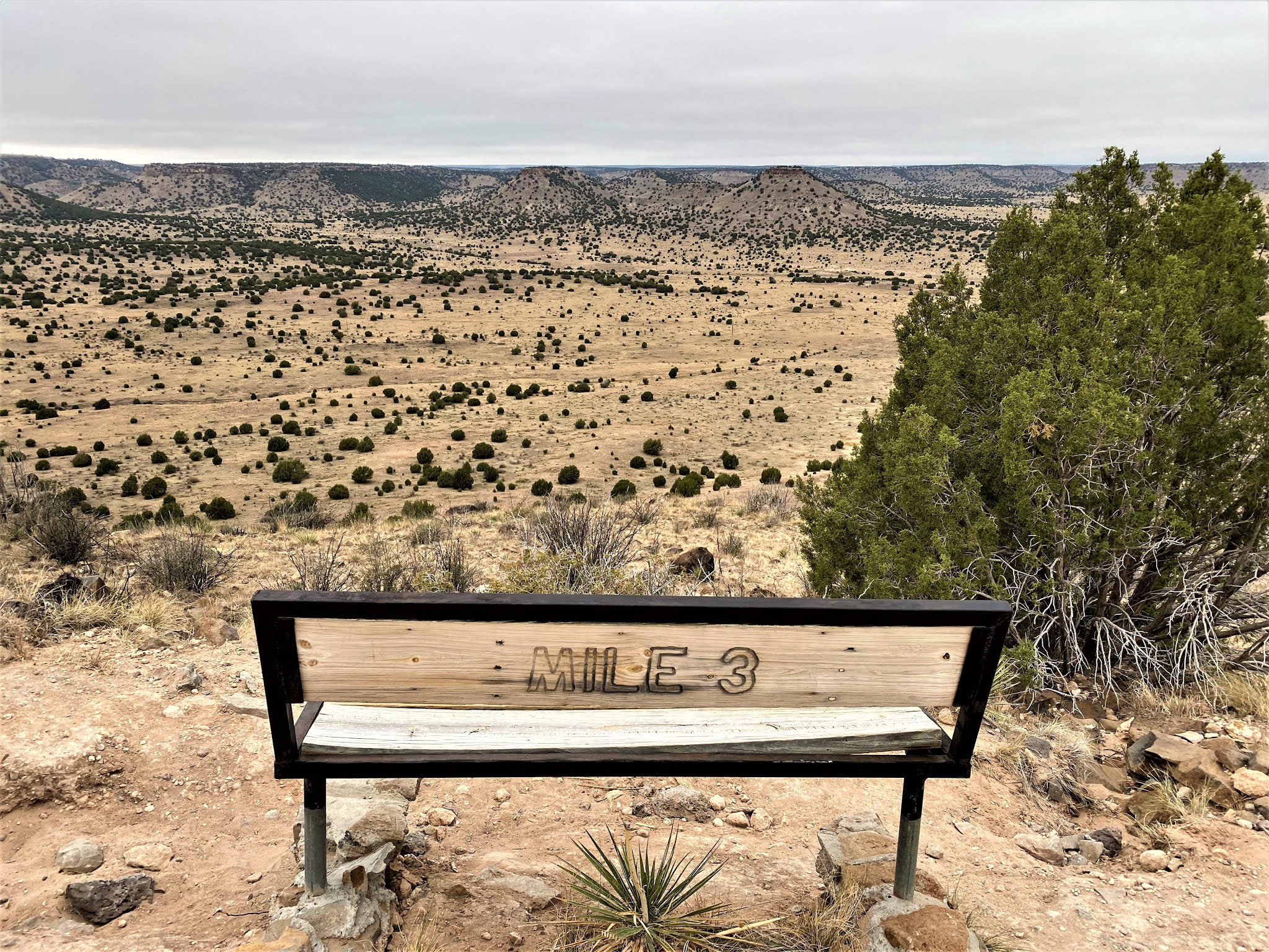
On closer inspection, we discovered the bench was being used as a mile marker. Very clever.

Onward. Before long, we could see what looked like a potential high point in the distance.

However, every path has its obstacles, and we ran up against a whole herd of them. We approached cautiously, and they slowly moved out of our way. For wanderers like us, I guess they are nicer than flying monkeys or orcs, right?

Aha! Mile 2!


This was the last flat stretch before heading uphill. The clouds were beginning to look ominous.

Mile 3 was located partway up the ascent to the top of the mesa. This spot actually has a view, so the bench faces the valley rather than the trail.
Finally on top of the mesa, but it was soooo cold and pretty windy. It looked even flatter than the valley we had started it. It was hard to imagine a high point up here!

Mid-October. Thirty-something degrees. Windy. Still blooming.


As you can see, I was much colder than Bob.


Someone had placed what looked like a fall centerpiece near the obelisk.


Thank you, Boy Scout Troop 251! I hope your bench gets lots of use.


The granite obelisk was quite a bit classier than the markers at the Nebraska and Kansas high points, and though we had to climb to get to this one, it was the lowest in elevation of the three.

Remember those signposts at Mount Sunflower telling distances to various cities? Here is the Black Mesa equivalent. Yeah, definitely classier. Note that Kansas is 53 miles east northeast of here, and New Mexico is only 1,299 FEET due west.


Texas is just 31 miles due south, and Colorado is just 4.7 miles due north.


This cairn, in contrast, looks like an ogre that might come alive at night.

A concrete bench would have been a nice resting place had it been just a little warmer.


As far as we could tell, we were the first people to hit the trail that day. We saw a total of sixteen other hikers before we got back to our car.


You know, they could make this hike a lot shorter by letting cars drive on this long, flat section that makes up over 2 miles of the 4+ miles to the summit. I guess that would bring more people to this out-of-the way place and diminish the experience. Besides, it was nice to feel like we were "hiking" when we were actually walking pretty quickly over flat ground. I figure we averaged about 3 mph, likely because of a combination of the cold and this flat stretch.

I loved the quirkiness of Mount Sunflower, the high point of Kansas, but this was probably the most fun of the three high points we visited. I'll take three hours of hiking over three hours on dirt roads that run through mile after mile of monotonous farmland any day.
We made a couple more stops in the afternoon on our way to our hotel. One was at Capulin Volcano National Monument, located in Northern New Mexico. At 8,182 feet, it was at a higher elevation than any of the three high points we had "summited" on this trip. Looking out at the valley from the lip of the crater, we could see what look like other cinder cones in the distance.

The Capulin Volcano, which is considered a perfect specimen of an extinct North American volcano, is a large bowl with a path on the rim. I wanted to walk it, but Bob was done walking for the day.

We continued on to Sugarite Canyon State Park, located on the Colorado-New Mexico state line.


This is Trinidad, a nice little town that reminds me of my hometown.

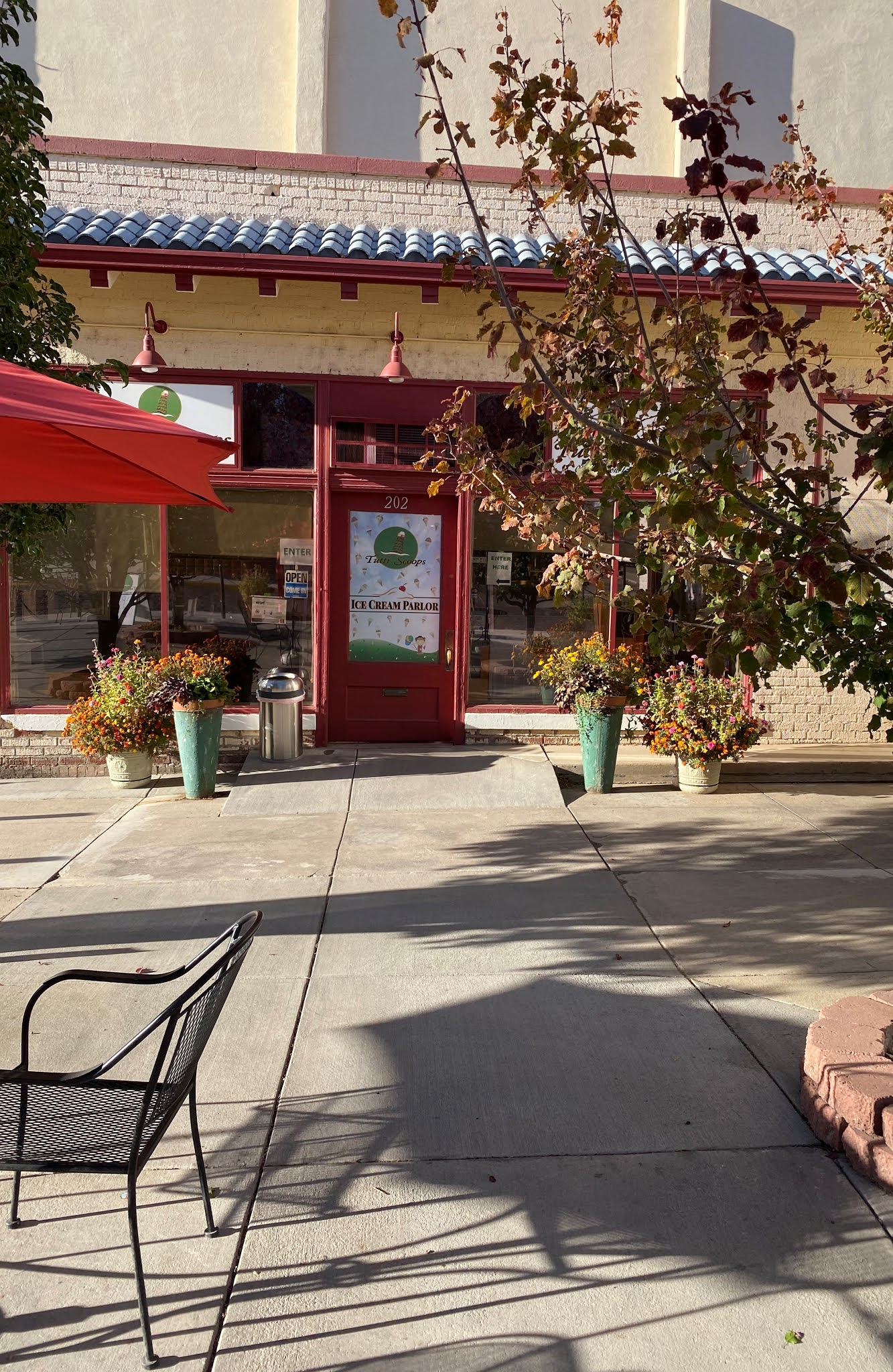
This was our last destination: Tutti Scoops. It helped make us feel a little better after being rejected by New Mexico.


We spent the night in Pueblo. We were on the road by 7:15 AM to catch our flight at the Denver Airport. Gotta love the Frontier planes. I wonder if they have some kind of rule about not having duplicate tails, at least not parked at the same airport?

This trip was evidence that no matter where you go, there is something interesting to see. Thanks for a good time, Bob, Master Trip Planner.
Black Mesa was a very nice change after two drive-up high points. This was my favorite day of the trip.
ReplyDelete