Sunday, December 31, 2017

URUMQI, CHINA: THE GRAND BAZAAR AND THE DIWOPU INTERNATIONAL AIRPORT

We didn't have a lot of time left in Urumqi after we visited the museum because we had to catch a plane to Kazakhstan, but there was enough time to spend an hour in the "International Grand Bazaar Urumqi." Opened in 2003, it has lots of booths and stalls selling clothing, jewelry, pottery, nuts, fruit, local cuisine, rugs, musical instruments, and just about everything you can imagine, so an hour was not nearly enough time, especially because Bob was On A Mission to find and eat some horse meat.

There are some very distinct things about this market that set it apart from other Asian markets we've been to. The first and most obvious is the Islamic architecture.

There is a grand entrance that includes a huge tower and a mosque.

First, the mosque. It was beautiful and extremely photogenic, but unfortunately we didn't have time to go inside:


The tower near the entrance looks like some of the centuries-old minarets we had seen in other places, but it's only fourteen years old. Tourists can pay $7-$8 to climb the stairs to the observation deck at the top, but unfortunately we didn't have time to go inside:

Saturday, December 30, 2017

URUMQI, CHINA: XINJIANG REGIONAL MUSEUM

Our last stop in China before we headed off to the Stans was Urumqi, the capital of the Xinjiang Autonomous Region and a major stop on the Silk Road. Another HUGE city by U.S. standards, it has a population of about 3.5 million, which makes it the largest city in Central Asia. In the Untied States, only New York City and Los Angeles have larger populations, and yet I had never heard of Urumqi before we began getting ready for this trip. Perhaps part of the reason for its lack of recognition is that it is pretty darn remote. In fact, the Guinness Book of Records says at 1,600 miles from the nearest seaport, Urumqi is the most remote major city (at least in terms of distance from the sea) in the world.

Urumqi's location is marked by red in the map of China below. The Xinjiang Region is the orange area:
Map from Wikipedia

As hard as it is to get there, Urumqi has some amazing things to see. We spent a few hours at the Xinjiang Regional Museum, famous for its mummy collection (known in this museum as "dried corpses").

A limited number of guests are allowed in the museum at intervals throughout the day in an attempt to control the crowds.

There was plenty of English on the signage, but not all of it was intelligible, such as this sign that invites guest to a "Whirling dance at the fingertips skills contributing to a craftsmanship."

Sunday, December 17, 2017

ON THE BUS FROM TURPAN TO URUMQI, CHINA: LEARNING WHAT MAKES THE CHINESE, CHINESE

We dreaded the three-hour drive from Turpan to our next destination, Urumqi. It looks like a tiny hop on the map below, but it is 120 miles on roads that wind up into the Tian Shan Mountains:

We weren't on a high speed train this time, but a regular Chinese bus:

However, we were fortunate to have Michael Wilcox, the lecturer brought along by our tour company, on board our bus. Michael earned a PhD from the University of Colorado and for many years taught at the LDS Institute of Religion at the University of Utah. This is the third tour we have taken with him as our lecturer (the first being a trip to Russia and cruise through the Baltic Sea, and the second being a trip to Israel and Egypt). On all three trips, I particularly appreciated how Michael encouraged us to look with new eyes at what we were seeing and to embrace the goodness of people, cultures, and doctrines in diverse places.

Thursday, December 14, 2017

TURPAN, CHINA: EMIN MINARET AND DINNER

Pre-Travel-to-Western-China-Me assumed that China is pretty much Buddhist Confucian, or Taoist, the latter two really being philosophies rather than religions. In reality, most Chinese are either non-religious or believe in a folk religion (no clergy or canonical scriptures, practices and beliefs handed down over time, etc.).

I was also surprised to learn that there is a strong Muslim community in Western China that makes up somewhere between 1-4% of the total population of the country, with most of the Chinese Muslims being Sunnis. In the autonomous region of Xinjiang where we spent the majority of our time when we were in China, most of the population is from the Turkic ethnic group Uyghur (pronounced wee-gur), and most of them are Muslims. When we continued our journey into the predominantly Muslim Stan countries later on this trip, it began to make sense why Western China, which borders many Muslim countries, has a strong Muslim population.

That said, I did not get the sense that it is a particularly devout Muslim population, probably due, at least in part, to the repressive Chinese government. Our guide AJ told us that he is Muslim, but that he doesn't practice, but maybe he will when he is old. Good ol' death-bed repentance--it bridges all faiths.

We stopped for a visit at the tallest minaret in China, the Emin Minaret. Built in a single year at about the time the Revolutionary War was ramping up in the United States (1777-1778), this architectural marvel stands 144 feet tall. Its base is 33 feet wide, and it tapers to an area about 10 feet wide topped by a small dome.


I would have loved to climb the interior stairs to the top, but the tower is closed to tourists.


We have seen many minarets gilded with precious metals and covered with tiles, but this is the first monochromatic minaret that I can recall seeing, and in some ways it is one of the most unique. A complex network of fifteen different geometric and floral shapes, occurring in bands that ring the tower, is created by carefully positioned clay bricks:


Monday, December 11, 2017

TURPAN, CHINA: JIAOHE RUINS (AKA YAR CITY) AND KAREZ CANALS

We followed our morning visit to the ruins of Gaochang with a visit to the ruins of the ancient Silk Road city of Jiaohe, also known as "Yar City" because of its location in the Yarnaz Valley. Like Gaochang, Jiaohe sprung up in about 100 BC and was deserted around 1400 AD. 

One of the things that makes Jiaohe so unique is its location on a plateau that rises 98 feet between two branches of a river. The best image I have of that is this map from the site:

The island is about 1,000 feet wide and a mile long. The river on each side provides a natural barrier, so Jiaohe is not enclosed in walls as are most ancient cities.


Paved walkways lead to the ruins:

. . . which are quite extensive and in varying states of preservation:

Tuesday, December 5, 2017

TURPAN, CHINA: FLAMING MOUNTAINS AND LUNCH

Before stopping for a bite to eat, our buses drove into the Flaming Mountains. I don't know if they got that name because of the red sandstone that forms them, or because this is the hottest spot in China, frequently reaching over 120℉ (but with a surface temperature of over 150℉), or because the eroded sandstone cliffs look like flames:

As we drove farther up the road, the landscape varied somewhat, but the absolute lack of vegetation did not:

We came to a large parking lot that appeared to be the end of the road. The scenery was very dramatic:

. . . and we were stunned to find a river running down a gorge lushly lined with trees. 

Saturday, December 2, 2017

TURPAN, CHINA: THE TAKLAMAKAN DESERT AND THE ANCIENT CITY OF GAOCHANG

Prior to visiting the Taklamakan Desert, I had never heard of it, even though at 130,000 square miles, it is slightly larger than the state of New Mexico and just a little smaller than the country of Germany. The old Silk Road split into a north road and a south road at the desert's edge, circumventing the extreme conditions that include temperatures as low as -15℉ in the winter and 110℉ in the summer. In addition to lack of water, a phenomenon known as "shifting sands," which is when wind-whipped sands cause dramatic landscape changes, further complicates a journey through this wasteland. Almost 85% of the Taklamakan Desert experiences shifting sands, making crossing its vast expanse especially treacherous.

It doesn't look too bad from the bus window:

. . . but the further we go, the drier it gets. I was glad it was October 3rd rather than August 3rd or January 3rd:

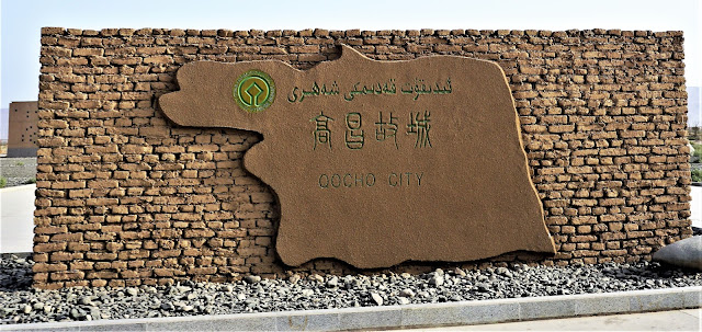
Our first stop was the ancient oasis city of Gaochang, located on the threshold of the Taklamakan Desert.

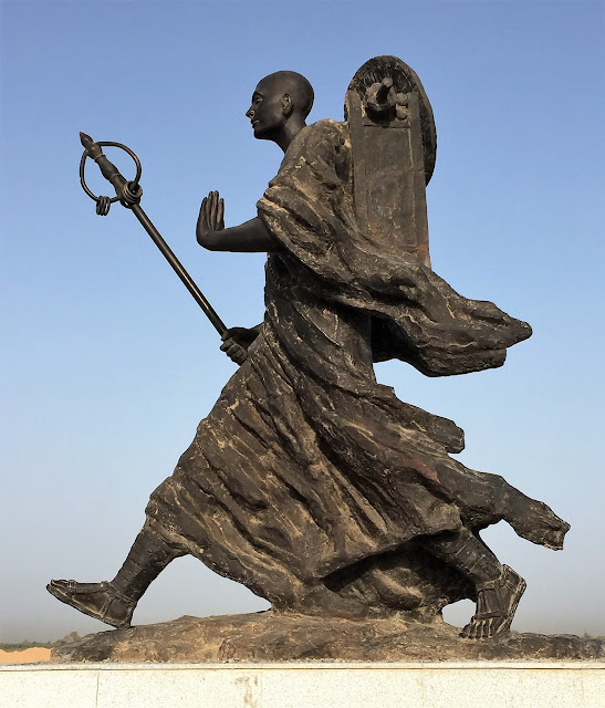
Waiting to greet us was our friend Xuanzang, the Chinese Buddhist monk who traveled to India, the heart of Buddhism, to acquire some Buddhist writings. (See previous post on the Great Wild Goose Pagoda.) When he passed through Gaochang in 628 AD, he stopped for a while to rest and lecture. Legend has it that the king grew so attached to him that he would not let him leave. Determined to continue his journey, Xuanzang went on a hunger strike. On the fourth day as he began to fail, the king finally released him to continue on his way.

I love his long, energetic stride. The combination of his flowing cloak and his backpack reminds me of wings:

A new visitors center prepares modern travelers for their stay in Gaochang:

Thursday, November 30, 2017

TURPAN, CHINA

After our visit to Dunhuang, we drove two hours in this bus:
We had three of these for our group
. . . to catch a high speed train to our next destination: Turpan.

We had to go through airport-like security on our way into the train station.  I had a bottle of water that was about 2/3 full. They had me drink some (presumably to make sure it was not acid or some kind of combustible). I thought that was quite efficient!

Bob bought a chicken drumstick for lunch at the "High iron" store at the station:

I was quite impressed by the sleek, modern train that traveled at 120 mph:
California has been trying to build a high speed train connecting San Francisco and Los Angeles for years and can't seem to make any progress. Here we were in the outposts of Western China taking a high speed train from nowhere to nowhere. I had Train Envy.

Tuesday, November 28, 2017

DUNHUANG, CHINA: THE MOGAO CAVES

Our last stop during the Dunhuang portion of our journey along the Silk Road was the Mogao Caves--also called Mogao Grottoes--another mind-blowing UNESCO World Heritage Site I had never heard of before this trip. 

I've decided that western China is ripe for a tourist explosion. They have clearly been working hard to build their infrastructure to support more tourism, and the sites themselves are also being developed to make them more accessible to foreigners, including the use of English descriptions.

Now if they would just add some more western-style toilets. In most of the places we visited in China (aside from our hotels), we had no option but squat toilets. I'm all for experiencing the local culture, but . . . 

Okay, okay, back to the caves. Our tour buses left our hotel early (7:30 AM) so that we could beat the crowds, but alas, it was the beginning of an eight-day national holiday in China, and so a lot of the locals had the same plan that we did. After a 30-minute bus ride, we went through a gate, got off the bus, and reboarded a shuttle bus for another 30-minute ride to the caves.

These man-made grottoes house 1,000 years of the largest collection of Buddhist art in the world. There are 735 caves, and so far 492 have been opened and restored to some degree. The caves in the photo below, seen from our shuttle bus, are still in their original state and are not open to tourists:

Note the caves on the far side of the dry riverbed:

The first caves were carved into the cliffs in the 4th century AD, and the final caves were created in the 14th century. There are 485,000 square feet of murals and more than 2,000 painted sculptures within those caves.

Saturday, November 25, 2017

CHINA: THE GREAT WALL OF THE HAN DYNASTY AND THE JADE GATE

Our next stop (in roughly the same area as the Yardang National Geopark) was the Great Wall of the Han Dynasty:

The symbols on the top of the above rock are the World Heritage symbol and the the UNESCO symbol:


We visited the Great Wall of China near Beijing about 10 years ago, and in my mind, that wall extended a great distance, always looking more or less like the section we saw.  I was quite surprised on this trip to discover how dumb I am when it comes to the Great Wall. There are multiple unconnected sections built over the period of a couple thousand years, and a lot of them don't look at all like the section near Beijing:
Map from here

The Han Dynasty started in 202 BC and ended in 220 AD. It followed the Qin Dynasty (when China was first unified, the Great Wall was started, the Terracotta Warriors were created, etc.). The Han Dynasty is considered to be the "Golden Age" of China. Much of the significant portions of the early wall were built during those years:
Map from here
The Silk Road trading route was in place by this time period, and this part of the wall was built as a defense against the pesky Mongolians.

The section we visited was in an area that looked very uninviting, and I wondered why anyone would come here, but as part of the Silk Road passage to and from the west, this region saw a lot of travelers:

  What remains of the wall doesn't look a thing like the Great Wall near Beijing:

Wednesday, November 22, 2017

DUNHUANG, CHINA: YARDANG NATIONAL GEOPARK

About 110 miles northwest of Dunhuang is a lonely section of desert known as Yardang National Geopark. It covers 154 square miles and is dotted with strange rock formations that developed over a 700,000 year period. The dictionary defines "yardang" as "a sharp, irregular ridge of compact sand lying in the direction of the prevailing wind in exposed desert regions, formed by the wind erosion of adjacent material that is less resistant."

Who knew?

A sign near one of the parking lots notes, "The major landscapes of this geo area include mound shaped, wall shaped, tower shaped and columnar Yardang landforms, which are very lifelike and has [sic] become the real ghost city in western China, and associated with the vast gobi and desert."

You get the idea, right?

The map below shows the numerous major formations in the park:

"Global Geoparks" became a category under UNESCO in 2015 and that designation was given to Yardang. By the way, China has 52 UNESCO World Heritage Sites, second only to Italy, which has 53. My guess is that as China continues to develop its tourist industry, it will soon take over the #1 spot.

The descriptions of various landforms on signs in the geopark make me smile. This one is the "Tower-shaped Yardang (Gold Lion Greeting Guests)," which "seems to be watching and welcoming tourists from afar":

Here he is:

Sunday, November 19, 2017

DUNHUANG, CHINA: EATING OUT, THE NIGHT MARKET, AND THE SUN GRAND HOTEL

Early on in this trip we determined to escape the massive tour group dinners as often as we could. Besides, Bob had heard of some regional delicacies in Dunhuang that he was pretty sure weren't going to show up on our plates at those generic meals, and he was determined to find a place where they would.

On our first night in Dunhuang, Bob asked Orlando (the name our Chinese guide chose for herself) if there was a place nearby that served donkey and camel meat, the specialties he was most interested in. She said there was and offered to take us there. It happened to be about two blocks from our hotel, a very short walk. We coerced coaxed Terry and Geneil to go with us and set off.

When we arrived, it appeared that we were the only guests in the restaurant, which was a bit of a concern since it was Saturday night. Orlando called the establishment "The Happiness and Lucky Restaurant," which may account for the almost all-red decor; red is the color that symbolizes both happiness and good luck for the Chinese.

We sat around a large round table, and before she left us, Orlando ordered from the all-Chinese menu, which was very helpful since we can read ZERO Chinese and the staff spoke ZERO English. We should have had Orlando arrange the price as well, but more on that later.

Bob had her order two donkey meat dishes and camel "three ways" (paw, hump, and generic meat). Terry and Geneil wisely ordered a chicken dish, but which turned out to be something other than chicken--perhaps goose? Our table was quite full: